Hours
Daylight visit recommended; check access locally
Pai · Mae Hong Son · Thailand
Cascading rock, flowing water and a cooler mountain setting
Mo Paeng Waterfall lies in the hills west of Pai, beyond the Santichon side of town. Its sloping rock surfaces and seasonal flow make it a contrasting nature stop after Yun Lai.
Hours:Daylight visit recommended; check access locally
Location:Wiang Tai, Pai District, Mae Hong Son 58130, Thailand
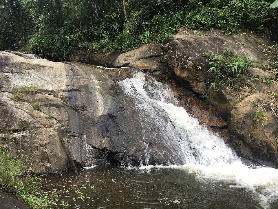
Mo Paeng is an outdoor waterfall area, subject to local site and environmental management. The public visitor sources consulted do not establish a single independently verified operator for all facilities; follow posted instructions and staff on the day.
The waterfall is a natural stream feature rather than a built heritage site. Water moving over bedrock has shaped smooth rock slopes and pools, while seasonal rain changes the size and speed of the flow.
Mo Paeng Waterfall lies in the hills west of Pai, beyond the Santichon side of town. Its sloping rock surfaces and seasonal flow make it a contrasting nature stop after Yun Lai. Watch the change in water flow between wider rock faces and narrow channels. Remain on safe ground, and do not treat natural rock slides or deep pools as supervised swimming facilities.
Wet rock is slippery, flash runoff can occur after rain, and swimming conditions are not guaranteed safe. Keep away from steep water edges.
There are no monumental buildings. Look for sloping exposed bedrock, water channels, pools and dense surrounding vegetation. The wet stone and foliage create strong textures for observation and photography.
Daylight visit recommended; check access locally
Check current entrance and parking arrangements on site
Travel west from Pai through the Santichon-side road network and navigate to Mo Paeng Waterfall specifically. Road conditions and the final walking section can vary after heavy rain.
The waterfall is a natural stream feature rather than a built heritage site. Water moving over bedrock has shaped smooth rock slopes and pools, while seasonal rain changes the size and speed of the flow.
There are no monumental buildings. Look for sloping exposed bedrock, water channels, pools and dense surrounding vegetation. The wet stone and foliage create strong textures for observation and photography.
Watch the change in water flow between wider rock faces and narrow channels. Remain on safe ground, and do not treat natural rock slides or deep pools as supervised swimming facilities.
Travel west from Pai through the Santichon-side road network and navigate to Mo Paeng Waterfall specifically. Road conditions and the final walking section can vary after heavy rain.
Reach the waterfall during daylight and assess water level.
Walk only on maintained or clearly permitted paths to safe viewpoints.
Take photographs and return before fading light or heavy weather.
Wet rock is slippery, flash runoff can occur after rain, and swimming conditions are not guaranteed safe. Keep away from steep water edges.
Use an established bank or stable viewpoint to frame the waterfall with foliage. Try a short exposure for texture or a steady longer exposure from dry ground; never balance on wet rock for a shot.
Pai town is the practical base, with options to combine Yun Lai, Santichon and the waterfall on a relaxed day.
Do not assume pools are supervised or safe. Judge conditions conservatively and follow any restrictions.
No. It is a separate hillside destination requiring its own road approach.
For up-to-date visitor feedback and review counts, consult the specific Google Maps place listing. This guide does not reproduce unverified scores.
Google Maps ↗Wiang Tai, Pai District, Mae Hong Son 58130, Thailand
Use this attraction’s own destination pin; confirm the final approach and transport arrangements before departure.
Open this place in Google Maps ↗Photo source and fact checking: Wikimedia Commons · Tourism Authority of Thailand