Hours
Daylight visits advised; check local access
Pai · Mae Hong Son · Thailand
Eroded earth paths south of Pai, with exposed slopes and wide views
Pai Canyon is a landscape of narrow earthen ridges and steep-sided gullies south of Pai town. It is a distinct geological experience from Yun Lai’s comfortable hilltop terrace.
Hours:Daylight visits advised; check local access
Location:Mae Hi, Pai District, Mae Hong Son 58130, Thailand
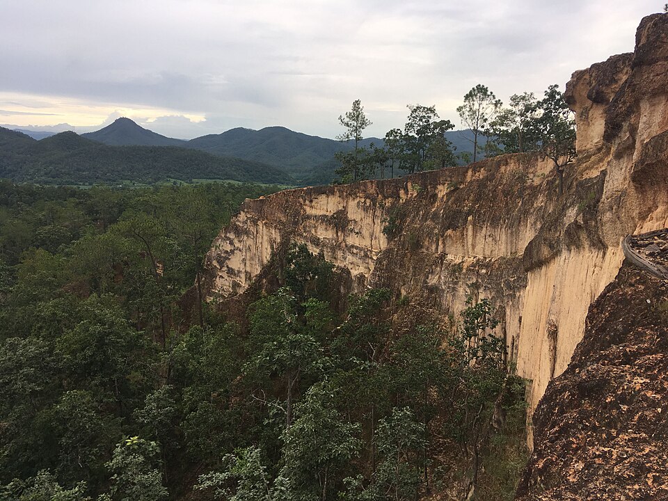
Pai Canyon is an outdoor natural attraction in the Mae Hi area. Published visitor guides do not establish a single named manager for every trail or viewpoint; follow locally posted rules and any public authority instructions rather than assuming it is operated by Yun Lai’s community.
The attraction is locally known as Kong Lan. Weathering and erosion have shaped channels and narrow ridges in the earth, producing the maze-like forms visitors see today. It is a landform, not a purpose-built architectural complex.
Pai Canyon is a landscape of narrow earthen ridges and steep-sided gullies south of Pai town. It is a distinct geological experience from Yun Lai’s comfortable hilltop terrace. From a secure viewpoint, observe the gullies and layers of earth; short walks are often sufficient. Sunset light warms the ridges, but returning after dark is riskier.
Exposed drops, loose soil, heat and wet-weather slips are serious hazards. Avoid cliff-edge selfies and turn back whenever the path feels unsafe.
There is no central historic building. The visual structure comes from thin ridgelines, exposed soils, branching paths and surrounding wooded slopes. Note the contrast between a relatively broad entry area and the narrow exposed sections farther in.
Daylight visits advised; check local access
Check any current visitor charges on site
Drive south from Pai toward Mae Hi and follow the dedicated Pai Canyon / Kong Lan pin. It is not adjacent to Yun Lai or Santichon; plan a separate journey, usually later in the day.
The attraction is locally known as Kong Lan. Weathering and erosion have shaped channels and narrow ridges in the earth, producing the maze-like forms visitors see today. It is a landform, not a purpose-built architectural complex.
There is no central historic building. The visual structure comes from thin ridgelines, exposed soils, branching paths and surrounding wooded slopes. Note the contrast between a relatively broad entry area and the narrow exposed sections farther in.
From a secure viewpoint, observe the gullies and layers of earth; short walks are often sufficient. Sunset light warms the ridges, but returning after dark is riskier.
Drive south from Pai toward Mae Hi and follow the dedicated Pai Canyon / Kong Lan pin. It is not adjacent to Yun Lai or Santichon; plan a separate journey, usually later in the day.
Arrive with enough daylight to assess the ground.
Walk only the sections appropriate to your footing and comfort.
Photograph from safe viewpoints, then descend well before darkness.
Exposed drops, loose soil, heat and wet-weather slips are serious hazards. Avoid cliff-edge selfies and turn back whenever the path feels unsafe.
Use the accessible viewpoint near the approach to create diagonal lines with the ridges. A wide lens conveys the terrain; do not step onto a narrow spine purely for a photograph.
Stay in central Pai if combining Yun Lai at sunrise and Pai Canyon in the late afternoon.
Easy viewpoints may be manageable, but exposed narrow ridges are unsuitable for some visitors and should never be obligatory.
Wet loose soil can be slippery. Consider postponing the ridge walk.
For up-to-date visitor feedback and review counts, consult the specific Google Maps place listing. This guide does not reproduce unverified scores.
Google Maps ↗Mae Hi, Pai District, Mae Hong Son 58130, Thailand
Use this attraction’s own destination pin; confirm the final approach and transport arrangements before departure.
Open this place in Google Maps ↗Photo source and fact checking: Wikimedia Commons · Tourism Authority of Thailand